Community Corner
A Scenic Dixie Highway No More
Stretching from county line to county line, the original Dixie Highway was laid out along a most scenic route following the Pasco County coastline.


First planned in 1914, the Dixie Highway was part of the National Auto Trail system that grew from an earlier road connecting Miami to Montreal. However, instead of a single paved road the final result was a series of small interconnected paved roads funded by individuals, businesses, local governments and states.
Today, that scenic coastal highway has morphed into the six-lane nightmare known as U.S. Highway 19.
In the beginning, the federal government played little role in the Dixie Highway. However, from the early 1920s through to 1927, increased federal funding ultimately resulted in the disbanding of what became known as the Dixie Highway Association. The road was then taken over as part of the United States route system with some sections becoming state highways.
Find out what's happening in New Port Richeywith free, real-time updates from Patch.
The portion of Dixie Highway that cuts through Pasco County,-- then known as State Road 5 but referred to as Paradise Loop-- was actually an alternate, scenic route, off the main Dixie Highway.
In January 1916 the Port Richey Post reported Pasco County had completed construction its portion of the road at a total cost of $135,000.
Find out what's happening in New Port Richeywith free, real-time updates from Patch.
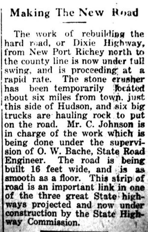
In 1919, newspapers reported the first improvements were already underway, doubling the road in size from 9 feet to 16 feet wide and with a new designation as State Road 15.
By 1932, road improvements were extended further south through Pinellas County with the road being designated as United States Highway 19, however this a much different U.S. 19 then we know today.
Crossing the north county line at Aripeka, the highway had an iron bridge spanning Hammock Creek, before proceeding south towards Hudson, where travelers could see the beautiful Gulf of Mexico nearly the whole way.
In Hudson, the Dixie Highway intersected Hudson Avenue, then known as Main Street. With the town’s post office and a small sundry story, residents commonly called this the Cross Roads. A little further south was the Fitzgerald filling station, the town’s only gas station.
From Hudson, the highway followed the present course of U.S. Highway 19-- slightly altered at today’s Scenic Drive-- until reaching what is now known as Grand Boulevard.
On its approach to New Port Richey, the highway entered some of the densest flatwoods of palmetto and scrub oak before meandering along the Pithlachascotee River. The highway passed through Sims Park and graced the shores of Orange Lake before reaching the downtown business district at Main Street.
South from New Port Richey, the road crossed the Pithlachascotee River via another magnificent iron bridge with similar construction to the one in Aripeka.
Finally connecting with what is now Alternate 19, today’s Mile Stretch Road in Holiday was the last leg of the coastal highway through Pasco County.
With major realignment from Chiefland to Bayonet Point, by 1946, the Dixie Highway was shifted to become a more modern two-lane, high-speed road. The section from Holiday to St. Petersburg was completed in 1951, and the present day U.S. Highway 19 was born, forever changing the west coast of Pasco County.
All along the roadway, numerous small filling stations, diners, hotels, motels, and tin-can camps popped up to make travels convenient for the high speed motorist. These conveniences eventually lead to and created the modern overdevelopment and congestion that we all know today.
A recent Dateline NBC investigation revealed the stretch of U.S. Highway 19 through Pasco County is among the most dangerous roads in the United States.
Mandated by the National Highway Traffic Safety Administration, a Florida Highway Patrol study beginning in 1998 and ending in 2003 recorded 262 fatalities on the section of highway from Pasco to Pinellas, an average of approximately 52 deaths per year. Of these, 100 were pedestrian related, making it the worst road in Pasco County.
The road's a key part of the new Pasco County West Market Redevelopment Plan. County staff now looks to transform U.S. 19 into a “livable roadway”. When completed, residents could witness a new era in the history of the former scenic Dixie Highway.
The first phases of the redevelopment plans are already being implemented by the Florida Department of Transportation with upgrades to transit facilities, driveway modifications, relocation of existing street lighting, and the addition of continuous right-turn lanes from county line to county line.


